GIS Integration for Urban Planning - Project
CLIENT
Urbis advises developers, property owners, investors, private firms, NGOs, community groups, industry associations, and all levels of government—local, state, and federal. Among their many services, they design and master plan urban developments, guide projects through the complex planning approval process, and help clients envision and create new spaces for work, leisure, entertainment, and commerce—from shopping malls to business parks and retirement living.
CHALLENGE
The company handles a significant amount of Geographic Information System (GIS) data. One of their challenges is structuring this data in a way that can be effectively presented to clients. The GIS team found themselves spending excessive time converting and translating the information into a presentable format.
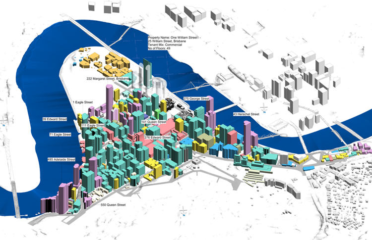
HOW AUTONOMATION SOLVED IT
AUTONOMATION developed a macro (Dynamo script) visual programming solution to load and utilise GIS information to automatically generate geometry. This script goes beyond basic GIS capabilities by offering a deeper understanding of spatial patterns and relationships. It allows users to zoom in and evaluate key information, such as project addresses, building heights, ownership details, zoning classifications under the City Council, and current labels (e.g., business, house, commercial property).
This script empowered our client to provide crucial information, demonstrating the impact of city planning project requirements. It offered invaluable insights to clients across all levels of government and the private sector.
The strength of the information generated by this script lies in its ability to predict the effects of planned construction, identify potential problems and impacts based on macro data, and present this information contextually in a concise and detailed manner. This bespoke solution is handed over to the client for continued use over time.
CLIENT OUTCOME SUCCESS
The immediate goal was to translate information more quickly, but Autonomation’s solution went beyond this to offer significant planning data. In the private sector, it provided valuable documentation and data sets, enabling clients to have more favorable discussions and outcomes with government entities. For government, the solution offered detailed data to present on current circumstances and potential challenges when changing zones or building, aiding them through the various phases of a project.